4 miles W of Selbyville (302) 378-2736
Managed by: Delaware Wildlands, Inc.
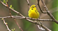
The Great Cypress Swamp is the largest remaining forested area on the Delmarva Peninsula. Low-lying, wet and densely vegetated, the swamp's inaccessibility has unquestionably aided its preservation. It is a treasure trove of typically southern breeding birds, beginning in mid to late April. Less explored by birders at other times of year, the area has potential to turn up interesting species at anytime. The unpaved Hudson Road loop is a good access point, traversing several forest types in a short distance.
The Great Cypress Swamp is a large area, with many landowners. Access is generally limited to public road edges. The non-profit conservation group Delaware Wildlands has preserved approximately 10,000 acres in the swamp.
Directions for the Hudson Road loop:
From US 113 just north of Selbyville, go west on Route 54 towards Gumboro. Just before the 3-mile mark, you will enter a nice patch of swamp forest. Birding here is not recommended, however, as the road shoulders are narrow. Instead continue on, watching carefully on the left (SE) for Hudson Road (Rd 418), which is reached 5.9 miles from US 113 (38°28'19.80"N 75°19'31.61"W).
Follow Hudson Road, which is unpaved, 0.5 mile, to where it bends sharply right (S). The forest along the next 0.5 mile is excellent. In another 0.7 mile, Bethel Road intersects Hudson from the right (38°27'14.87"N 75°19'48.17"W). Continuing straight on Hudson will take you almost immediately across the Maryland-Delaware state line, and into more forest. To return to Route 54 from the Bethel-Hudson junction, go right (NW) on Bethel 0.7 mile, then turn right (N) on Donaway Road (38°27'34.92"N 75°20'31.31"W), which rejoins Route 54 in 0.9 mile.
Other Birding Sites in the Cypress & Pine Region:
- Great Cypress Swamp
- Trap Pond State Park
- Redden State Forest
- Nanticoke Wildlife Area & Chapel Branch